Nazca Lines
From Wikipedia, the free encyclopedia
| Lines and Geoglyphs of Nazca and Pampas de Jumana | |
|---|---|
| Name as inscribed on the World Heritage List | |
 | |
| Type | Cultural |
| Criteria | i, iii, iv |
| Reference | 700 |
| UNESCO region | Latin America and the Caribbean |
| Inscription history | |
| Inscription | Unknown (18th Session) |
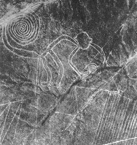
The Nazca Lines /ˈnæzkə/ are a series of ancient geoglyphs located in the Nazca Desert in southern Peru. They were designated as a UNESCO World Heritage Site in 1994. The high, arid plateau stretches more than 80 km (50 mi) between the towns of Nazcaand Palpa on the Pampas de Jumana about 400 km south of Lima. Although some local geoglyphs resemble Paracas motifs, scholars believe the Nazca Lines were created by the Nazca culture between 400 and 650 AD.[1] The hundreds of individual figures range in complexity from simple lines to stylized hummingbirds, spiders, monkeys, fish, sharks, orcas, and lizards.
The designs are shallow lines made in the ground by removing the reddish pebbles and uncovering the whitish/grayish ground beneath. Hundreds are simple lines or geometric shapes; more than 70 are zoomorphic designs of animals such as birds, fish, llamas, jaguars, monkeys, or human figures. Other designs include phytomorphic shapes such as trees and flowers. The largest figures are over 200 m (660 ft) across. Scholars differ in interpreting the purpose of the designs, but in general, they ascribe religious significance to them.
 Due to the dry, windless, and stable climate of the plateau and its isolation, for the most part, the lines have been preserved. Extremely rare changes in weather may temporarily alter the general designs. As of recent years, the lines have been
No comments:
Post a Comment